The U.S. is being slammed by extreme weather of all kinds this week, with frigid cold temperatures freezing the central states and catastrophic wildfires scorching California.
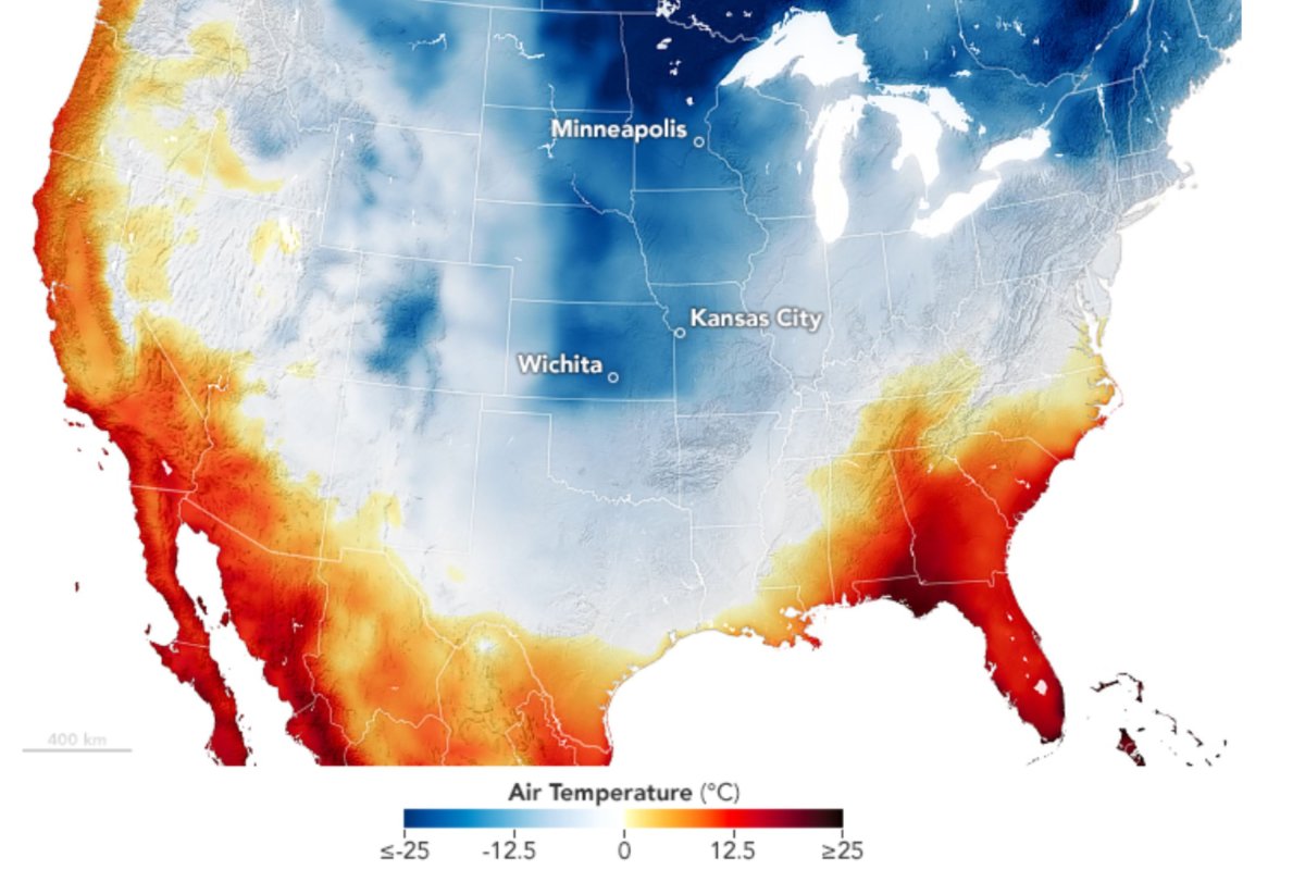
A NASA image reveals the huge variation in temperatures across the country on January 6, plummeting as low as -22 degrees F in the northern Midwest, but reaching as high as 77 degrees F in parts of Florida and California.
This map was made using the GEOS (Goddard Earth Observing System) model and represents the temperatures at 6.5 feet above the ground.
Much of the Midwest has been in the grips of severely cold temperatures, with thick snow falling across many states. Some areas of Kansas saw as much as 18 inches of snowfall, breaking state records.

As of today, January 8, large areas of the southeast are blanketed in Winter Storm Watches and Advisories, with Winter Weather Advisories issued for New Mexico, Texas, Montana and the Northeast.
"A developing Winter Storm will produce snow and rain/freezing rain, icing, over parts of the Southern Plains and Lower Mississippi Valley late Wednesday night into Thursday," the National Weather Service said in a Short Range Public Discussion.
Several more inches of snowfall are forecast for these regions, with whiteout conditions in others due to powerful winds.
"Persons should consider delaying all travel. If travel is absolutely necessary, drive with extreme caution. Consider taking a winter storm kit along with you, including such items as tire chains, booster cables, flashlight, shovel, blankets and extra clothing," the NWS said in a Winter Storm Watch.
❄️Significant snowfall affected the Central Plains, Ohio Valley, and Mid-Atlantic regions over the weekend. Here are some preliminary snow totals associated with the system from January 4-6. For more information, visit the Storm Summary page at https://t.co/2iFgBJVxfa ❄️ pic.twitter.com/NPmxj2kbkm
— NWS Weather Prediction Center (@NWSWPC) January 7, 2025Meanwhile, in California, the strong Santa Ana winds have whipped up four intense wildfires in Los Angeles, which have claimed two lives already and destroyed over 1,000 structures, according to the Associated Press.
Conditions were primed for wildfires, with the recipe for ideal fire weather including: "strong winds; low humidity; steep terrain; very flammable vegetation such as the Chapparal shrubs that are typical in the hills around LA," Stefan Doerr, director of the Centre for Wildfire Research at Swansea University, told Newsweek.
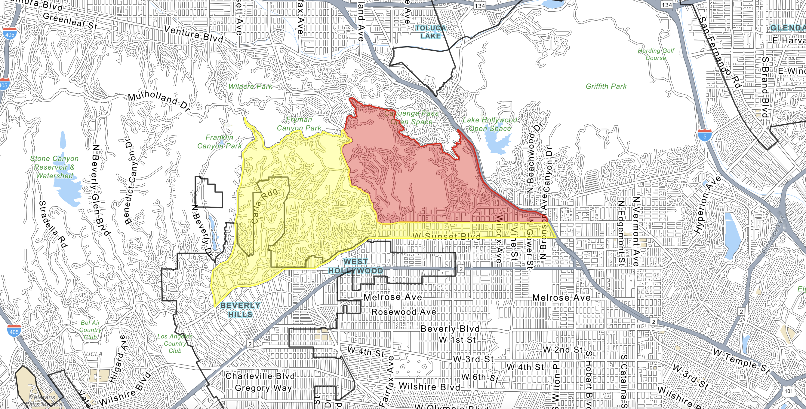
The Palisades fire in the Pacific Palisades has grown to 2,925 acres in size, burning only miles away from the 2,227-acre Eaton Fire near Altadena, the 505-acre Hurst Fire in San Fernando Valley, and the 75-acre Woodley Fire near Burbank. CALFIRE notes that all of these blazes are also "0 percent" contained.
Winds are expected to remain strong across the coming days, making it harder for firefighters to stem the flames.
Winds gusts past 2 days: https://t.co/te8O8tAR8T
Some highest gusts:
Mt Lukens Truck Trail (SCE) 100 MPH
Magic Mtn Truck Trl (SCE) 90 MPH
Saddle Peak 98 MPH
Hollywood-Burbank Airport 84 MPH
Eaton Cyn (SCE) 70 MPH
"Sustained winds reaching 30 to 40 mph, with stronger winds in the terrain, along with low relative humidity, and dry fuels will contribute to the dangerous conditions. Critical fire weather conditions are expected to continue on Thursday for portions of Southern California," the NWS said.
Do you have a tip on a science story that Newsweek should be covering? Do you have a question about weather? Let us know via science@newsweek.com.
![SOURCE SPORTS: [WATCH] Mets Capt. David Wright Gives Interesting Insight On The Honor Of His Jersey Retirement In Citi Field](https://thesource.com/wp-content/uploads/2025/01/01fs75fy836w8mp4ytwr.webp)


 English (US) ·