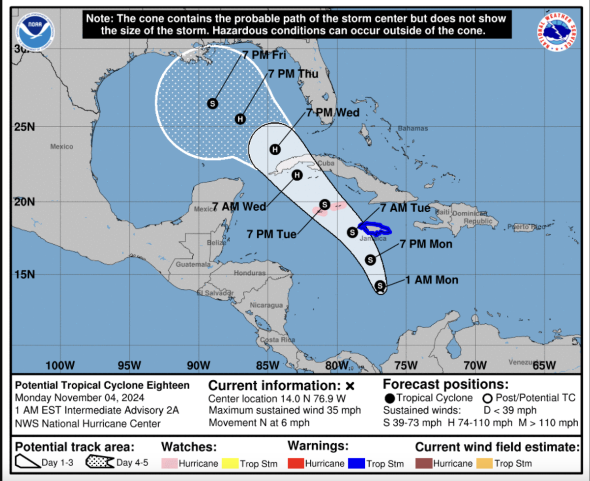
The National Hurricane Center has forecast a possible tropical storm that could form today and head toward Florida.
The storm is known as Potential Tropical Cyclone 18 but will be named Storm Rafael if it intensifies into a tropical storm.
In its 10 p.m. ET advisory on Sunday, The National Hurricane Center reported that the current disturbance is expected to become a tropical storm on Monday night as it passes near Jamaica.

The low-pressure system is then forecast to become a hurricane in the Northwestern Caribbean by Tuesday as it hits the Cayman Islands and parts of Cuba.
While the winds will likely not be hurricane-strength when they hit the U.S., it is warned that midweek the system will likely bring heavy rain across parts of the Western Caribbean, which could then spread northward into Florida and adjacent areas of the Southeast US.
Newsweek has contacted the National Oceanic and Atmospheric Administration for comment.
In its advisory, the National Hurricane Center also warned that interests in the Florida Keys should keep a close eye on Rafael as hurricane and tropical storm watches could be needed across the Keys today.
In an X, formerly Twitter, post, the National Weather Service for Tampa Bay clarified what the storm might mean for Florida. The NWS said "it [the storm] enters the Gulf by mid week with increasing rain chances and a 10%-20% chance of tropical storm winds for coastal areas, though the core of the storm could remain far enough offshore to prevent a higher wind threat."
In another post, NWS Miami and South Florida warned that the "developing pressure gradient" of Potential Tropical Cyclone 18 would likely result in "a windy stretch of days for South Florida with hazardous marine and beach conditions continuing."
Explaining the possibilities for Rafael, AccuWeather Chief On-Air Meteorologist Bernie Rayno said:
"The future track will depend on the movement of a dip in the jet stream more than 1,000 miles away over the U.S. next week," he added.
"If that jet stream dip pushes far enough to the east, it will tend to scoop up the tropical feature and possibly draw it across the southeastern Gulf of Mexico and into South Florida.
"But, if the jet stream dip lags to the west, the tropical feature may push into the western or central Gulf of Mexico, where it could threaten areas as far to the west as Louisiana or Texas. There's also the possibility it continues due westward and diminishes over southern Mexico," Rayno said.
The Atlantic Hurricane season draws to a close on November 30. The unusual levels of high activity at the end of the season due to near-record high water temperatures in the Atlantic Basin for this time of year.
Storms in November are rare but not impossible. On record, only four Hurricanes have hit the U.S. in the penultimate month of the year.
The most recent was when Hurricane Nicole hit Florida in November 2022 as a category 1 storm.


 English (US) ·