Hurricane Kristy is barreling across the eastern Pacific Ocean and is unlikely to make landfall, new models show.
Hurricane Kristy strengthened into a Category 3 hurricane on Wednesday. While it remains an unlikely direct threat to North and Central America, it could cause "life-threatening" surge along the West Coast, forecasters have said.
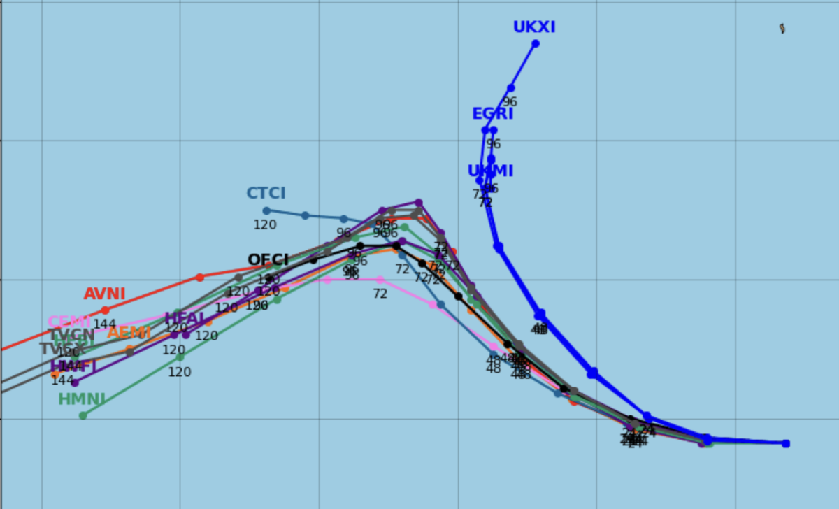
Spaghetti models is a nickname given to the weather models that show potential tropical cyclone paths. When shown together, the individual model tracks can resemble strands of spaghetti. If the lines are clustered together, it means there is a higher level of confidence in the storm's projected path.
A spaghetti model produced by Tropical Tidbits showed the vast majority of pathways are indicating that Hurricane Kristy will stay away from North and Central America. It will continue to track westward over the Pacific Ocean, although there is one outlier that shows it could turn course toward northern Mexico and the U.S.

However, the National Weather Service is appearing confident that Kristy will stay over the Pacific Ocean. The NWS wrote on X, formerly Twitter, yesterday: "No danger to land, Major Hurricane Kristy is churning its way across the Pacific today."
"Kristy is moving toward the west near 20 mph (31 km/h), and a westward to
west-northwestward motion is forecast through Thursday," the National Hurricane Center (NHC) reported in its latest update at 8 a.m. PDT on Wednesday. "A slower northwest to north-northwest motion is expected by late Friday."
The NHC said Kristy is "expected to fluctuate in strength over the next day or so," with "steady to rapid weakening" taking place by early Friday and dissolving over the weekend.
There will be some impacts to land along the West Coast, however. "Swells generated by Kristy will affect portions of the west coast of the Baja California peninsula late this week and over the weekend," the NHC has reported. "These swells are likely to cause life-threatening surf and rip current conditions."
Storms that originate in the Atlantic or Pacific Oceans typically travel westward, which makes those from the Atlantic a more significant danger to North America, like the recent hurricanes Milton and Helene.
Pacific Ocean storms tend to be less of a landfall threat, but if one pushes or originates closer to land, strong winds and storm surges are not uncommon along Western coastlines. Last year's Hurricane Hilary, which originated in the Pacific, delivered destructive winds and torrential rain to Southern California after it made landfall as a tropical storm in Mexico.
Hurricane season in the Eastern Pacific began on May 15, two weeks before the Atlantic season started. Both end on November 30.


:quality(85):upscale()/2024/04/24/878/n/3019466/36c5693c662965c5d1ce91.72473705_.jpg)
 English (US) ·