The fires in Los Angeles County have grown so large they can be seen from space, as satellite images have revealed the impact of the devastating blazes sweeping across the area.
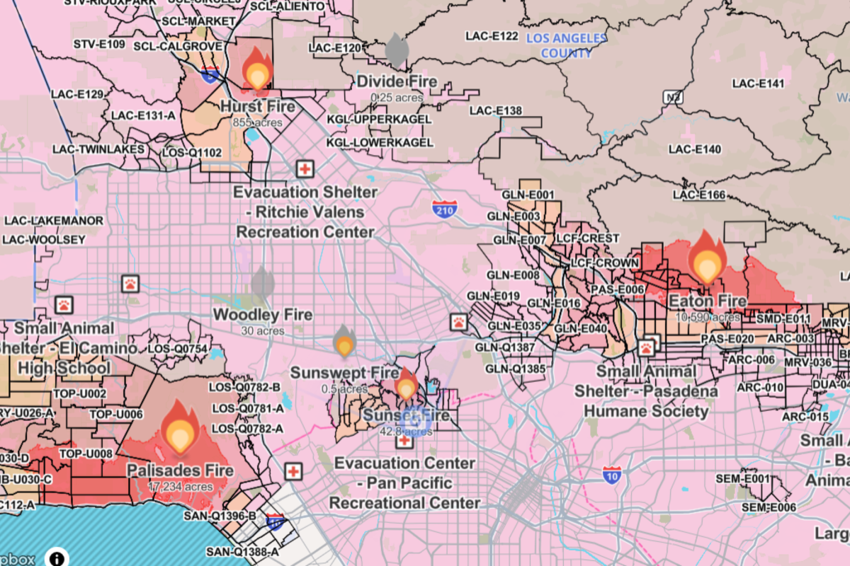
Images taken by the National Oceanic and Atmospheric Administration (NOAA)'s GOES-West Satellite show just how much the county's two biggest blazes, the Palisades and Eaton fires, which are burning in the Pacific Palisades and the Pasadena/Altadena regions of LA, have grown since they started on January 7.
Firefighters are also battling several other fires in the county, including the Sunset, Hurst, and Lidia fires.

Why It Matters
LA County is the most populated county in America. So far, at least 70,000 residents have been told to evacuate due to these fires, and 1.5 million more were without power as of the afternoon of January 8.
LA is used to wildfires, however these fires are occurring outside of "fire season," and are being fueled out of control by high Santa Ana winds and unseasonably dry conditions.
LA Fires Latest
California received a Federal Disaster Declaration on January 8 to allow for Federal Emergency Management Agency (FEMA) aid in the area.
There are now more than 7,500 local state and federal firefighters on the ground, as well as 1,162 fire engines, 23 water tenders, six air tankers, 31 helicopters, and 53 dozers fighting the fires.
Where Are the California Wildfires Now?
While firefighters were able to contain 40 percent of the Lidia fire, and 10 percent of the Hurst fire, another fire, the Sunset fire, broke out on Wednesday night prompting a new evacuation order in the Hollywood Hills.
The two major fires from January 8, the Palisades and the Eaton fires are continuing to blaze.
In times of bad weather, it’s good to have both emergency and non-emergency phone numbers on hand to assist you and your neighbors. Please share with your friends and family in Pasadena. pic.twitter.com/apUNlzXxq8
— City of Pasadena (@PasadenaGov) January 8, 2025The Palisades fire was burning at 2,921 acres at midnight on January 8, and is now at 17,234 acres 24 hours later. Similarly, the Eaton fire has spread from 1,000 to 10,590 acres within a day.

What People Are Saying
California Governor Gavin Newsom: "To the heroes, firefighters, and first responders battling these fires in Los Angeles: Your sacrifice and determination inspire the entire state. California is deeply grateful for your dedication and service."
President Joe Biden: "We're prepared to do anything and everything, as long as it takes, to contain the Southern California fires and help reconstruct. But we know it'll be a hell of a long way. The federal government is here to stay as long as you need us."
LA Fires Forecast
The California Department for Emergency Services has warned that Southern California is "not out of the woods," as the high winds and dry conditions are expected to continue fueling the fire through Friday.
The Eaton and Palisades fires are still at 0 percent containment, despite the amount of personnel on the ground.


 English (US) ·