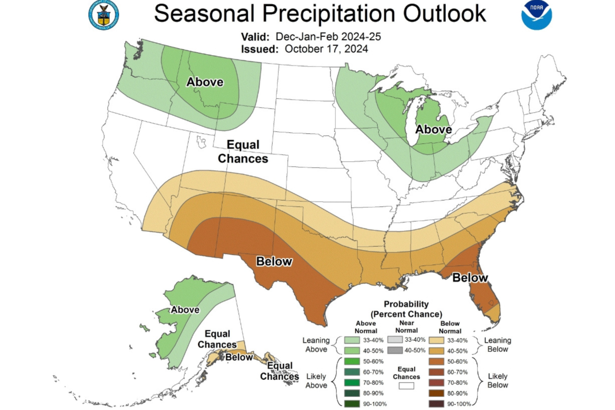
A map of the U.S. published by the National Weather Service (NWS) Climate Prediction Center in October shows which states could see more snowstorms this winter.
With La Niña conditions expected to develop this fall, storms will adopt a more northerly track across the U.S. during the winter months, according to the forecast. This means that states in the Pacific Northwest and the Great Lakes region are expecting above-average precipitation—which could come in the form of snow, given low winter temperatures—whereas Southern states are more likely to be drier and warmer than average.
"This winter, an emerging La Nina is anticipated to influence the upcoming winter patterns, especially our precipitation predictions," said Jon Gottschalck, chief of the Operational Prediction Branch of the NWS Climate Prediction Center, in the forecast.
Newsweek reached out to the NWS by email for comment.

States Expecting a Wet Winter
As winter persists, the Climate Prediction Center anticipates that the wettest winter conditions will occur in northeastern Washington, northeastern Oregon, northern and central Idaho, western Montana, northwestern Alaska, all of Michigan, much of Wisconsin, northern Indiana and northwestern Ohio. Those states have a 40 to 50 percent chance of seeing above-average precipitation through February, the forecast said.
The greatest chances for below-average precipitation are in southeastern Arizona, southern New Mexico, southwestern Texas, southern Georgia and much of Florida.
However, the forecast doesn't mean Southern regions aren't expecting any snow. As of Friday, New Mexico was several days into an early-season winter storm that was burying parts of the state in multiple feet of snow. The historic storm was expected to break 48- and 72-hour snowfall totals for several parts of the state, NWS Weather Prediction Center meteorologist Marc Chenard told Newsweek.
Meanwhile, drought conditions could worsen across the Central U.S. and the Southern Plains states during the winter months.
"Unfortunately, after a brief period in the spring of 2024 with minimal drought conditions across the country, more than a quarter of the land mass in the continental U.S. is currently in at least a moderate drought," said Brad Pugh, operational drought lead with the Climate Prediction Center. "And the winter precipitation outlook does not bode well for widespread relief."
What About Winter Weather in California?
The forecast also anticipated that California, which saw back-to-back above-average rain and snow totals the past two years, courtesy of atmospheric rivers battering the state during the winter months, was likely to "have equal chances of below-average, near-average or above-average seasonal total precipitation," the forecast said. The same is expected for the Central Plains states and the I-95 corridor from Boston to Washington, D.C.
However, AccuWeather's winter forecast anticipates that atmospheric rivers will target Northern California during the first half of winter, then shift to hit Southern California in January before returning to Northern California for the remainder of the winter.
Atmospheric rivers are a "long, narrow region in the atmosphere—like rivers in the sky—that transport most of the water vapor outside of the tropics," according to the National Oceanic and Atmospheric Administration.


 English (US) ·