New forecast maps indicate that parts of the country are set to experience a reprieve from the icy temperatures that hit much of the U.S. during early January.
Why It Matters
The Arctic polar vortex has been pushing icy winds throughout the nation, with swathes of the U.S. blanketed in snow.
Half of the country was under either winter storm warnings or winter weather advisories from the National Weather Service (NWS) as of early Friday.
These forecasts could represent a welcome respite from the freezing temperatures that have gripped much of America.
What To Know
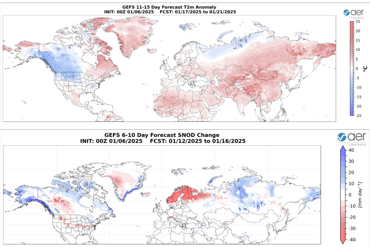
In an update from Atmospheric and Environmental Research, a forecast map showed "normal to above normal temperatures" expected in parts of the Southern and Northeastern U.S. for the period of January 17 to 21.
States included parts of Texas, Louisiana, New Mexico, Arizona, Nevada, Utah and Colorado, as well as New Jersey, Pennsylvania, New York, Vermont, New Hampshire and Maine.
However, the map implied that lower-than-average temperatures could still be expected in many Northern and Northwestern states during this period.
These included Washington, California, Idaho, Montana, Wyoming, North Dakota, South Dakota, Minnesota, Nebraska and Kansas.

A separate forecast map featured in the update suggested that, over the period of January 12 to 16, warmer temperatures would support snowmelt in parts of the Western, Southern and Central U.S.
States expected to see snowmelts included parts of Virginia, Kentucky, Idaho, Kansas, Missouri, Ohio, Indiana, Illinois, Montana and Wyoming.
According to the NWS, the Arctic polar vortex is a powerful band of west-to-east winds that develops in the stratosphere, about 10 to 30 miles above the North Pole, during the winter season.
It is always present near the poles, though it weakens during summer and strengthens in winter.
During winter in the Northern Hemisphere, the polar vortex can expand, pushing cold air southward along with the jet stream, the service said.
What People Are Saying
The Atmospheric and Environmental Research report said: "During the third week of January, the Alaskan ridging will shift to near the Aleutians, allowing for more widespread troughing across North America. This pattern favors normal to above normal temperatures across Alaska and much of Canada with normal to above normal temperatures across the Eastern U.S. However, during the third week of January, below normal temperatures will become more widespread across Alaska, Canada and the Northwestern U.S."
What Happens Next
Forecasts are subject to change. Atmospheric and Environmental Research issues updates regularly during the winter.
Do you have a story we should be covering? Do you have any questions about this article? Contact LiveNews@newsweek.com


 English (US) ·