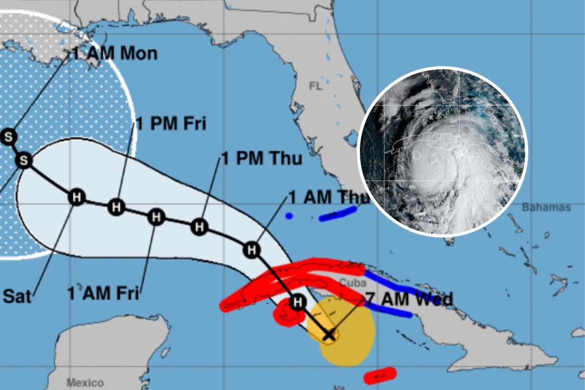
Residents in the Florida Keys have been warned that powerful storm surges could be headed their way as Hurricane Rafael barrels across the Gulf of Mexico.
Rafael, which is currently a Category 2 hurricane with wind speeds of 100 mph, will make landfall in Cuba today before sideswiping the Florida Keys on its journey northwest toward the Louisiana coast.
Up to 2 feet of storm surge is forecast for the Lower Florida Keys, which may cause some destruction along the coast due to flooding.
"Prepare for locally hazardous surge having possible limited impacts across the Florida Keys," the National Weather Service (NWS) Key West said in a local statement.

Potential impacts may include "localized inundation with storm surge flooding mainly along immediate shorelines and in low-lying spots, or in areas farther inland near where higher surge waters move ashore," as well as damage to marinas and piers, and moderate beach erosion.
Storm surges are caused by the intense, sustained winds of a hurricane pushing vast amounts of ocean water toward the shore. As the storm approaches land, this water has nowhere else to go, so it piles up and creates a storm surge.
Storm surges along the southern Cuban coast, on the other hand, may reach between 9 and 13 feet as Rafael approaches today.
"There is high confidence that human-caused climate change has already increased the intensity of rainfall in the storms, and that these increases will continue to compound until the warming stabilizes," Mathew Barlow, a professor of environmental, earth and atmospheric sciences at the University of Massachusetts Lowell, told Newsweek. "Storm surge is also increasing with sea level rise."
Rafael is due to possibly reach Category 3 strength today before it makes landfall along the coast of Cuba. Hurricane warnings are in place in the Cayman Islands and several Cuban provinces, with tropical storm warnings across more Cuban provinces, Dry Tortugas, and the Lower and Middle Florida Keys from Key West to the west of the Channel 5 Bridge.
"Rafael is expected to strengthen to near major hurricane intensity before reaches western Cuba and the Isle of Youth today. A hurricane warning is in effect for this region, where damaging hurricane-force winds, life-threatening storm surge, and destructive waves are also expected," the National Hurricane Center (NHC) said in a forecast discussion.
However, according to the NWS Key West, there is a less than 20 percent chance of seeing sustained tropical storm force winds (over 39 mph) in Key West, with a lower than 10 percent chance in Marathon and Layton.
The hurricane is anticipated to bring up to 10 inches of rain in some regions of Cuba, which may trigger flash flooding or mudslides.
"Rafael will bring areas of heavy rain across portions of the Western Caribbean through early Thursday, including the islands of Jamaica and the Caymans along with western Cuba. Flash flooding and mudslides are expected along the higher terrain in western Cuba," the NHC said.
Up to 3 inches of rain are forecast for Jamaica and in the Lower and Middle Florida Keys, and there is also some potential for tornadoes in the Florida Keys.
The NWS Key West warns residents to prepare for the intense wind and rain, which may lead to "damage to porches, awnings, carports, sheds, and unanchored mobile homes," "a few roads [becoming] impassable from debris, particularly within urban or heavily wooded places," as well as power outages and potential flooding.
The storm will then carry on across the Gulf of Mexico heading northwest, possibly making landfall in Louisiana at the weekend or early next week. Exactly how strong it will be and where it will make landfall is still unclear this far out, however.
"It is too soon to determine what, if any, impacts Rafael could bring to portions of the northern Gulf Coast," the NHC said.
The hurricane is forecast to weaken after making landfall in Cuba due to the atmospheric conditions over the Gulf.
"Once the system moves over the Gulf of Mexico, the environment should become increasingly less conducive for Rafael to maintain its intensity. Increasing southwesterly shear, significantly drier air, and gradually decreasing SSTs [sea surface temperatures] are likely to result in weakening," the NHC said.
Do you have a tip on a science story that Newsweek should be covering? Do you have a question about hurricanes? Let us know via science@newsweek.com.


 English (US) ·