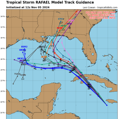
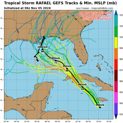
Storm Rafael's projected path appears to have shifted, according to new hurricane "spaghetti" models.
Rafael formed over the Caribbean yesterday and is predicted to reach hurricane intensity tonight as it reaches the Cayman Islands. It is due to reach Cuba on Wednesday and was initially projected to then follow a path into the Gulf of Mexico, possibly making landfall in the northern Gulf Coast on Saturday.
However, new spaghetti mapping from Tropical Tidbits, an Atlantic hurricane information and forecasting site, shows Rafael may divert eastward up through southeastern Alabama and into Georgia. Some lines on these maps show the possibility of Rafael crossing right across Florida.


"A High Risk of rip currents continues for area beaches through Saturday night, and high surf is likely by Thursday night," the National Weather Service for Mobile, Alabama, said on X, formerly Twitter, on Tuesday. NWS Mobile said beaches from Dauphin Island in Alabama to Destin, Florida, are likely to be affected.
Spaghetti models are named after their spaghetti-like appearance and are used to illustrate the potential path of a storm. If the lines are close together, it means that there is more confidence in the projected path.
Despite the updated mapping, there is discrepancy between the European and American storm models for Rafael.
European models suggest it will take a western path through the Caribbean and into the Gulf of Mexico toward Louisiana and Mississippi, while American models project the more easterly path through Alabama, Georgia and central and northern Florida.
Matt Devitt, chief meteorologist for WINK News in southwest Florida, noted the discrepancies between the two models in a post to X.
TROPICAL UPDATE: Interesting split between the European and American model ensembles (possibilities) for the track of #Rafael. American more east (yellow), European more west (orange). Consensus model has shifted more east the past 24 hours, but the core is still expected to stay… pic.twitter.com/HO4SE6RZfB
— Matt Devitt (@MattDevittWX) November 5, 2024"Interesting split between the European and American model ensembles (possibilities) for the track of #Rafael. American more east (yellow), European more west (orange). Consensus model has shifted more east the past 24 hours, but the core is still expected to stay off the Southwest Florida coast. We get outer bands, but overall manageable impacts," he posted.
Newsweek has emailed Matt Devitt for more insight.
Despite weakening considerably as it heads toward the U.S., the National Hurricane Center (NHC) warned that Rafael will bring heavy rain that will spread into Florida and adjacent areas of southern U.S. later in the week. The NHC continues to advise residents on the northern Gulf Coast to closely monitor any updates to the forecast.
Describing what impact Rafael will have on the Caribbean, the NHC reported that "Heavy rainfall will impact areas of the Western Caribbean with the heaviest rainfall occurring over Jamaica and portions of Cuba through midweek. Rainfall totals between 3 to 6 inches with locally up to 9 inches are expected. Flooding and mudslides could occur over portions of Jamaica and Cuba. Tropical-storm-force winds extend outward up to 105 miles (165 km) from the center."
The Atlantic Hurricane season officially ends on November 30, meaning that hurricanes are rare this month but not impossible, with forecasters saying that unusually high Atlantic Ocean temperatures could fuel more tropical storms.
On record, only four hurricanes have made landfall in the U.S. in November, the most recent being Hurricane Nicole in 2022.


![[SEE IT] Joakim Noah Opens Up About Rivalry with LeBron: ‘I Had Enough’ of His ‘Arrogance’”](https://thesource.com/wp-content/uploads/2025/01/Screen-Shot-2025-01-10-at-2.57.18-PM.png)

![[WATCH] Jim Jones Sees Drake’s Legal Moves Against UMG and Spotify as ‘Power Moves’](https://thesource.com/wp-content/uploads/2025/01/Screen-Shot-2025-01-10-at-2.46.43-PM.png)


 English (US) ·