A new blast of frigid Arctic air will be sweeping the country this weekend and next week, according to forecasters, bringing subzero and below-average temperatures to millions of Americans.
The weather conditions are expected to be so intense that Donald Trump decided to move his inauguration inside the Capitol Rotunda on Monday, saying he didn't want "to see people hurt, or injured, in any way." It will be the first time since Ronald Reagan was sworn in for a second term 1985 that a president's inauguration isn't held at the Capitol's West Front.
Why It Matters
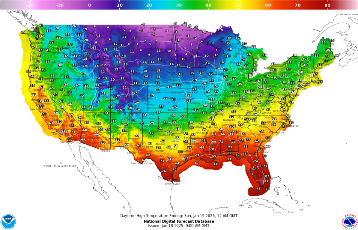
Millions of Americans will be bracing for extremely cold temperatures these coming days. According to the National Weather Service (NWS), a blast of Arctic air heading south will plunge over the Rockies, Plains, and Midwest on Saturday and will hit the East Coast on Sunday night as it moves off toward the Atlantic.
The agency warned that dangerously cold wind chills of 30-55 degrees below zero are expected across the Rockies, northern Plains, and upper Midwest on Sunday and next week, where they will pose a life-threatening risk of hypothermia and frostbite to exposed skin.
What To Know
Extreme cold watches issued by NWS meteorologists are currently in place in parts of Colorado, Idaho, Indiana, Kansas, Kentucky, Maryland, Michigan, Nebraska, North Carolina, Ohio, Pennsylvania, Virginia, Washington, D.C., and West Virginia.
Extreme cold warnings are in place in Minnesota, Montana, North Dakota, and Wisconsin.

The NWS wrote on Saturday that the Arctic air plunging south across the Southern Plains and eastward across the Ohio Valley today will produce "the coldest air of the season thus far, and in many cases the coldest in several years."
While temperatures are expected to plunge below zero in the northern Plains and Upper Midwest, the central Plains and Midwest would see the thermometer with highs between the teens and the 20s, and the southern Plains and lower Mississippi Valley would report highs between the 20s and the 30s. Forecast highs will be in the 40s along the western and central Gulf Coast.
What Does an Extreme Cold Warning Mean?
NWS meteorologist Jason Anglin previously told Newsweek that an extreme cold warning is issued when "life-threatening cold" is expected or occurring in an area.
According to the agency, people living in areas under an extreme warning watch should avoid going outside, or dress in layers if they do so, avoiding exposed skin.
How Is a Warning Different From an Extreme Cold Watch?
An extreme cold watch is issued when dangerously cold air temperatures or wind chill values are possible. Those in areas under extreme cold watches should avoid going outside in the coldest times of the day and make sure their cars have at least half a tank of gas.

What People Are Saying
The NWS Weather Prediction Center wrote on X on Saturday: "A trifecta of impactful winter weather systems will bring about bitterly cold temperatures, heavy snow to the Northeast, & both disruptive snow & ice accumulations to much of the Southern U.S. over the next seven days."
NWS Morristown, TN, wrote on X: "Extreme cold is expected for the first half of next week. Dangerously cold wind chills are expected area-wide. Many places will be below freezing from Sunday night through Wednesday night. While not unprecedented, it is something that only happens a couple of times per decade."
What's Next
The cold front that started in the Rockies on Thursday night is expected to move eastward and reach as far south as the upper Florida peninsula over the coming week, bringing unusually cold temperatures to much of the country. According to Fox Weather, more than 300 million Americans will experience below-average temperature for this time of the year by Monday.


 English (US) ·