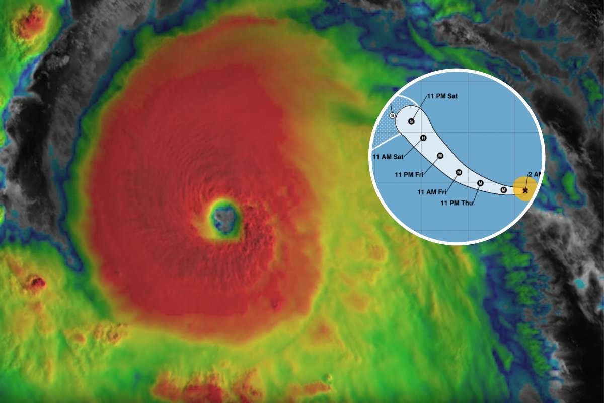
Hurricane Kristy has strengthened into a Category 5 storm in the Pacific Ocean, forecasters said on Thursday.
Kristy, formed from the remnants of Atlantic Tropical Storm Nadine earlier this week, is moving westward across the Eastern Pacific. The National Hurricane Center (NHC) on Thursday said Kristy's maximum sustained winds have increased to near 160 mph with higher gusts.
Where Is Hurricane Kristy Now?
The storm has been veering off to the west, and forecasters expect it to keep a westward to west-northwestward movement through the day. The NHC has predicted Kristy will then go in a northwest to north-northwest motion on Friday.

Will Hurricane Kristy Hit the United States?
Kristy is not expected to impact the U.S. However, it may cause dangerous waves off the coast of Baja California in Mexico.
"Swells generated by Kristy will affect portions of the west coast of the Baja California peninsula late this week and over the weekend," the NHC said on Thursday. "These swells are likely to cause life-threatening surf and rip current conditions."
What's Next for Kristy?
According to the NHC, Kristy is expected to see "some fluctuations in intensity" through tonight before "rapid weakening expected to begin Friday."
Kristy is projected to continue moving northwestwards across the Pacific before weakening back down to a tropical storm.
"The environment quickly becomes hostile with strong wind shear, drier air and cooler sea surface temperatures along the forecast track of Kristy," the NHC said. "The NHC intensity forecast follows these trends, showing rapid weakening, and now has the remnant low status at 72 h, and dissipation at 120 h."
How Is Kristy Different From Other Recent Storms?
Kristy is a Pacific hurricane, meaning it follows a much different path than those seen in the Atlantic, like Hurricane Milton and the others that have impacted the U.S. this year.
Atlantic hurricanes often move toward the U.S. mainland or the Caribbean islands, while Pacific hurricanes tend to move away from the Mexican coast and head out to the open ocean, although they occasionally affect Mexico or Hawaii.
Hurricane Kristy is the 11th named storm of the eastern Pacific hurricane season.
The Atlantic hurricane season runs from June 1 to November 30, while the Pacific hurricane season runs from May 15 to November 30 in the Eastern Pacific and from June 1 to November 30 in the Central Pacific.
"The eastern Pacific basin extends from Mexico and Central America westward to 140°W. Based on a 30-year climate period from 1991 to 2020, an average eastern Pacific hurricane season has 15 named storms, 8 hurricanes, and 4 major hurricanes," the NHC said in a webpage. "The first named storm typically forms in early to mid-June, the first hurricane tends to form in late June, and the first major hurricane forms in mid-July."
This year, the first hurricane in the eastern Pacific was Carlotta, which formed in early August. It was preceded by two tropical storms.
This article includes reporting from The Associated Press.


 English (US) ·